

|
|
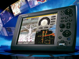
Marine Chartplotters for Marine Navigation from Furuno, JRC, RayMarine and More |
|
| A chartplotter is a device used in marine navigation that integrates GPS data with an electronic navigational chart (ENC). The chartplotter displays the ENC along with the position, heading and speed of the ship, and may display additional information from radar, automatic information systems (AIS) or other sensors. As appropriate to particular marine applications, chartplotters may also display data from other sensors, such as fishfinders and sonar.
Chartplotters are rugged, reliable, and essential to safe navigation. With integrated GPS and RADAR, today's chartplotters offer the very best, safest and secure way to travel on the water. We offer Chartplotters from premier providers. Electronic chartplotters always require a processor, or sometimes multiple processors. It is a feature of the implementation, and sometimes of regulatory requirements, whether the processor is a general-purpose one that can run other applications, or must be dedicated to the chartplotter application. Considerable processing power and video memory can be needed, especially when the chartplotter generates three-dimensional displays, as used for fishing. |
|
| Marine Chartplotters All Products Index in Alphabetical Order |
 |
|
|
|
Chartplotters
Marine Chartplotters for Marine Navigation from Furuno, JRC, RayMarine and More
A chartplotter is a device used in marine navigation that integrates GPS data with an electronic navigational chart (ENC). The chartplotter displays the ENC along with the position, heading and speed of the ship, and may display additional information from radar, automatic...
[Show More]
Contact us today for a free consultation!
Furuno Chartplotters
Garmin Chartplotters
JRC Marine Chartplotters
Koden Chartplotters
Lowrance Chartplotters
Raymarine Chartplotters
Si-tex Chartplotters
Simrad Chartplotters
Standard Horizon Chartplotters
All Products Index in Alphabetical Order


 W/19\" Display")


 or Competitor Product to TZ Professional")

